Detecting phytophagy from space
ST357
Description
Quantifying tree defoliation by insects over large areas is a major challenge in forest management, but it is essential in ecosystem assessments of disturbance and resistance against herbivory. However, the trajectory from leaf-flush to insect defoliation to refoliation in broadleaf trees is highly variable. Its tracking requires high temporal- and spatial-resolution data, particularly in fragmented forests.
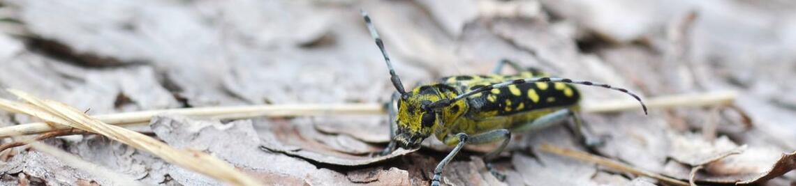
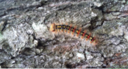
In a unique replicated field experiment manipulating gypsy moth Lymantria dispar densities in mixed-oak forests, we examined the utility of publicly accessible satellite-borne radar (Sentinel-1) to track the fine-scale temporal trajectory of defoliation. The ratio of backscatter intensity between two polarizations from radar data of the growing season constituted a canopy development index (CDI) and a normalized CDI (NCDI), which were validated by optical (Sentinel-2) and terrestrial laser scanning (TLS) data as well by intensive caterpillar sampling from canopy fogging.
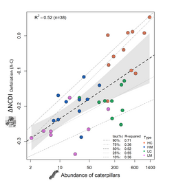
The CDI and NCDI strongly correlated with optical and TLS data (Spearman’s ρ=0.79 and 0.84, respectively). The ΔNCDI significantly explained caterpillar abundance (R2=0.52). The NCDI at critical time-steps and ΔNCDI related to defoliation and refoliation well discriminated between heavily and lightly defoliated forests.
The results published in Methods in Ecology and Evolution (Bae et al. 2022) demonstrate that the high spatial and temporal resolution and the cloud independence of Sentinel-1 radar potentially enable spatially unrestricted measurements of the highly dynamic canopy herbivory. This can help monitor insect pests, improve the prediction of outbreaks, and facilitate the monitoring of forest disturbance, one of the high priority Essential Biodiversity Variables, in the near future.
Duration
since 2020
Publications
Bae S, Levick S, Heidrich L, Magdon P, Leutner BF, Wöllauer S, Serebryanyk A, Nauss T, Krzystek P, Gossner MM, Schall P, Heibl C, Bässler C, Inken D, Schulze E-D, Krah F-S, Culmsee H, Jung K, Heurich M, Winter M-B, Fischer M, Seibold S, Thorn S, Gerlach T, Hothorn T, Weisser WW, Müller J (2019) Radar vision in the mapping of forest biodiversity from space. Nature Communications 10:4757.
Bae S, Müller J, Förster B, Hilmers T, Hochrein S, Jacobs M, Leroy BML, Pretzsch H, Weisser WW, Mitesser O (2022) Tracking the temporal dynamics of insect defoliation by high-resolution radar satellite data. Methods in Ecology and Evolution 13: 121-132.
Leroy BML, Lemme H, Braumiller P, Hilmers T, Jacobs M, Hochrein S, Kienlein S, Müller J, Pretzsch H, Stimm K, Seibold S, Jaworek J, Hahn WA, Weisser WW (2021) Relative impacts of gypsy moth outbreaks and insecticide treatments on forest resources and ecosystems – an experimental approach. Ecological Solutions and Evidence 2:e12045.
Funding
Bavarian State Institute for Forest and Forestry (LWF)